Red Rocks Randonnée 600 — The Inaugural Ride

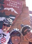
For several years, I have tinkered with the idea of doing a Grand Randonnée in the national parks of southern Utah. A Grand Randonnée has the minimum distance of 1200 km (750 miles), over a 90-hour time period (just over 3-1/2 days). During the fall and winter of 2013, I begin working on some routes. I wanted the riders to be able to visit one national park (or monument) each day — hopefully daylight hours too. I mapped out literally dozens of routes on Ride with GPS, and finally settled on this one. During the early part of 2014 I got it approved as a RUSA “permanent” which means can be ridden any time and not on a scheduled day. It is called the Red Rocks Randonnée 1200.

My intent was during the 2014 season, to ride two 1200Ks (celebrating the fact  that I just turned 60). I was hoping to ride this one during the spring of 2014, but couldn’t find enough others to join me. During this time, Jim Halay, a resident of Eden Utah and a member of Salt Lake Randonneurs, a group I manage, needed a 600K ride to qualify for a 1200K coming up. So I decided to quickly design a 600 km shortened version of this route and then just do it. We were joined by none other than Debra Banks, a very active randonneur (or randonneuse to be exact) from Sacramento. She is also the designer/owner of Rivet Cycle Works, which makes some killer suspended leather saddles. (Read her blog report of this ride here.)

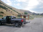
Finally, on June the 3rd (2014), at 4 a.m. we started off, leaving our motel in Kanab Utah (elevation 4,953 ft, very near the southern border of the state). This was a self-supported ride. The local temperature was in the upper 60s, so most of us wore minimal clothing as we heading south towards the Arizona border. After less than eight miles we were in Arizona and the temperature was dropping to the upper 40s. Rather than stop and add layers, we just kept riding, toughing it out. After 50 cold miles, we came to our first checkpoint in Apple Valley, a Chevron c-store. We immediately stepped inside to the warmth of the building and consumed some breakfast foods. The sun was just rising over the bluffs to the east.

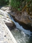
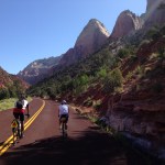
Staying together as a small group, we proceeded on our way, dropping in elevation to the low point of the ride, which was in Hurricane Utah, elevation 3,248 ft. The forecasted high was in the upper 80s or low 90s, but it was still early morning so we were not feeling the heat of the day yet. We climbed out of Hurricane up to Springdale and through the entrance to Zion National Park. Our route continued along the valley floor, with spectacular views of the red canyon walls, some 3,000 feet tall. Our route ended at the end of the road, which is called the Temple of Sinawava. This location is also the exit point for those walking up the Virgin River doing the legendary Zion Narrows. We topped off our water bottles and reversed our route, dropping in elevation as we followed the Virgin River downstream along Highway 9.

We then started climbing in earnest as we got on and off I-15, heading north to Cedar City. At one point, Deb and I stopped under a freeway overpass to cool down as we waited for Jim. He arrived and kept on riding past us. After finishing our conversation (mostly trade talk stuff) and topping off our internal radiators, we continued the climb, hoping to catch Jim. As it turns out, he pulled off in Cedar City to rehydrate and the two us, having stopped earlier, unknowingly went past him. The three of us later regrouped at another c-store at the north end of Cedar City. From there we continued north and finally got off the interstate for the last time and onto SR-20 for the final climb of the day. This climb was approx. 1,700 vertical. The grade was not steep, but continuous. Deb and I grabbed a third bottle of water at the last checkpoint and carried them along with us for this anticipated climb in the late afternoon heat. The climb topped off at 7,863 feet, just as the sun was beginning to drop near the horizon. That was at mile 208 for the day. We made a quick descent down to US-89 and then eight flat miles into our overnight destination in Panguitch at mile 229.

Jim and I drove through Panguitch the prior day, on our way to Kanab. While doing this, we left off some drop bags with our overnight supplies at our designated motel at the Owen’s Travel Center (truck stop). I choose this location for the overnight stop because it is the only spot in the area a with 24/7 c-store. Deb, on the other hand, overnighted a FedEx box of supplies for herself to this location. We arrived at around 8:30 p.m. We knew that the pizza place next to the motel closed at 9:00 p.m., so we went directly there, instead of checking into our motel. After a much-needed supper, we checked into our motel and decided to resume our ride at six the following morning. The elevation at Panguitch is rather high at 6,600 ft.

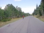
The three of us ate breakfast (from our drop bags mostly) and heading out into the chilly air. It was 29F, but we bundled up well, unlike the previous day. This part of the route takes in a few rollers, before making a 1,100-foot climb to the east, up a nicely paved bike trail. From there it heads south, climbing again, towards Bryce Canyon National Park. Before the entrance we stopped at Ruby’s Inn General Store. Compared to the Panguitch truck stop/c-store, this was a super-market, with many choices of groceries and food. Most of grabbed some sort of frozen “delight” and microwaved it and then we sat on the south-facing benches of this store, enjoying the warming rays of the morning sun.

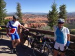
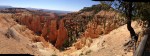
From Ruby’s Inn, we made our way into the park and visited several lookouts, some of which were on the cue sheet and some that were not, doing some recon for future brevets. Unlike Zion, in Bryce you are looking down into the canyons and riding along the top of a ridge inside this beautiful park. The early morning light provided great views of the many hoodoos in this park (sandstone spires). Finally, after exiting the park we proceeded back down to highway 89 and headed south towards Kanab, generally loosing elevation, but into the typical prevailing SW wind.

We later stopped in the small town of Hatch, finding a decent c-store (news to me…will be noted on future cue sheets) and then kept on going towards Mt Carmel Junction, which is near the eastern entrance to Zion. After grabbing supper at the local Subway (mile 337), we made another climb up to the junction to Coral Pink Sand Dunes and headed south to this state park, leaving busy highway 89. My shoes, which were some two months old, were giving me issues and I had developed a nice blister or callous spot on my right pinky. These shoes were a tad too narrow and so I had them loosely buckled, causing my foot to slide forward, making matters worse. I finally took an unneeded arm warmer and stuffed it under the buckle, as I had the buckle tightened all the way, but the shoe was still too loose. This helped a lot, but the damage was done. After more climbing and a short descent, we arrived at the state park. There was water and restrooms there which we needed as we were now in the later afternoon heat of southern Utah.

Soon, we realized that we had only approx. two hours to finish this ride and had 20 miles to go. This permanent must be finished in 40 hours or it is considered a DNF. We left briskly and made a u-turn, and after a short climb, we were rewarded by a quick descent on a rather rough, patched and potholed paved road (Hancock Road) back down to US-89. I am glad it was daylight, as I would not want to be descending this crappy road in the dark! But at least there no traffic along this section of road. We then had some easy gradual downhill miles back to our motel in Kanab, arriving with only 45 minutes to spare. Our generous sleep stop and side trips in Bryce Canyon really cost us time and nearly cost us the whole ride!

My GPS/Strava download indicated a little over 17,000 feet of climbing. A few seasons ago, I did the Grand Canyon 600, which had approx. 20,000 feet of climbing and also had similar wild temperature variations (from 33F to 95F). This one rates up there as “one of my toughest 600s.” When designing the route, I actually tried and tried to reduce the climbing, but simply couldn’t do it without cutting out one of the parks and diluted the very essence of this route. Afterwards, we stopped by a local BBQ restaurant to top off our tanks once again. Deb spent the night in Kanab and Jim and I made the drive home, stopping a few times for truck-stop cat naps.

Meanwhile, it will be impossible for my tiny RUSA region to support a full-blown 1200K, unless it is essentially a self-supported event, which means no meals at the overnight stops. This could be a problem as neither of the two key central cities on this route (Panguitch and Kanab) have any 24-hour restaurants, only 24-hour c-stores. The 1200K Red Rocks route has about 30,000 feet of climbing. This is not be the toughest 1200 out there, but it certainly rates high. Consequently, I am rethinking the whole thing. I have now designed a new 1000K route and may try to do this in the fall of 2014 as a permanent. I’m seriously considering adding three ACP “Red Rock” choices for the 2015 season — a 400, 600 & 1000, all starting at the same time and date and roughly following the same route.

Shoulder Injury

20130922-184238.jpg
Wave one (some 300-350 cyclists) of this event at 06:00. A nice 70F with little wind, til later when the wind picked up to the mid 20s.

This past week I was selling my bags at the registration check in for the the Viva Bike Vegas Gran Fondo (we ran out of several colors of our wildly popular “Top Tube Century Bag”). I also did this ride on Saturday and injured my left shoulder during this 104-mike event. In my six years of cycling, this is the first time I sustained an injury that required medical attention. In a nutshell, I was descending one of those narrow paved bike trails that are very curvy. (Yes I know, the reason they make those trails curvy is so cyclists don’t go too fast!) There was loose gravel and/or dirt on either side of the trail. I felt I was going too fast for the turn, so I deliberately overshot it and went onto the shoulder and dumped into the rather soft gravel on the edge of the pavement. (According to my GPS Strava download, my speed was 38 MPH.  Zoom in on the satellite view at mile 85.6.) Although it hurt a bit quite a bit if I moved it, I was able to get back on the bike and finish the event.

I knew something was wrong because the left shoulder looked different from the right (there was an obvious protrusion on the left side, which was not found on my right side…need I say more?), indicating that it was either broken or possibly dislocated. After a trip to the emergency room it was determined that it was a torn AC ligament. This means essentially that I will require just a lot of rehab. My first appointment with an orthopedic surgeon indicated that with this type of grade 3 injury, that surgery  may be the best long term option. But that is not necessarily the opinion of others. I am now seeking a second opinion.

X-Ray of the grade 3 separated collar bone or AC.

New 200K P.R. (Personal Record)

Goshen Canyon with the first fall snow on Mt Nebo in the background.
Goshen Canyon with the first fall snow on Mt Nebo in the background (photo shot on a prior ride).

I’m finally catching up on some old news that I should have posted long ago….

When I first started cycling, one of longstanding goals (bucket list) was to ride a 200km (124.3 miles) brevet in under 8 hours. Most brevets I did were in small groups or solo, so drafting was not always possible. Finally, after about two years of riding, I managed to finish a few solo 200s in under eight hours. One season, I did two or three back to back 200s where my time as 8:03 or 8:04, but I usually did one or more under eight hours per season.

This past fall, about two weeks after finishing the 200-mile LoToJa race in under 12 hours (another item off the bucket list) I was riding “my monthly 200K.” I had no intention of setting any personal records, but just to finish in perhaps under eight hours. This is the link to this route, which has about 5,000 feet of climbing. As the day progressed, I noticed that the wind seemed to always be in my favor (or lack thereof) and that this ride was going rather quickly. I only stopped twice for hydration and some snacks at convenience stores. Towards the end of the day, after making the 45-minute climb up Salt Creek Canyon and as I was dropping into the town of Fountain Green, it appeared that maybe if I did keep pushing, I might get a sub 7-hour ride — something I had never done before…solo or with a group. So I mustered up all my remaining strength and for the last 40 minutes of the ride. I kept down in my aerobars and focused on keeping good form and not slowing much for nutrition and drinking. Nearly totally exhausted, I made the final slight climb up to my last turn at the light in Mount Pleasant — my timer showed I only had about 40 seconds left on the clock. I blew through the light (right turn, red light I think) and sprinted the four blocks to the Maverik c-store, which was my “finish” for this ride, punching my GPS as I passed by the store. I DID IT, leaving only six seconds to spare!

Since I rarely “race,” I find beating personal goals a means of improving my fitness. This is a prime example of such an event. I was totally spent, but took a 15 minute break before making the 400-foot climb back to my house.

The official brevet card or record of the ride.
Screen shot of my GPS download. This is slightly confusing because it also includes the 5 minute ride from my house to the start of the official 200K.


2012 LoToJa—Finally, a New PR for Me! (200 under 12)

Ever since I started road cycling in 2007 I have had the goal of doing a double century (200 mile) ride in under 12 hours. On Desperado Dual (central Utah ride) I have come close…12:20, 12:35, but with the winds and sparse drafting opportunities I never achieved my goal. This spring I went to Calif. and did the Solvang Double but we had incredible head-winds for the last half so I missed my goal again. So this year I decided to try LoToJa, which held every September (Logan, UT to Jackson, WY). I think there was about a thousand rides. Since this is a sanctioned “race” and not a “tour” or brevet, everyone tended to move more quickly. This event is the longest sanctioned road race in America.

I teamed up with a few local friends, Brian Whipple and Richard Anderson. We signed up as a team in the Citizen Class, Category 5, age 35+ and ending up with a start time of 7:13 a.m. The morning of the ride was pretty typical with temperatures at about 45F as I recall. I did not wear long finger gloves and wished I had as they were very numb for the first 90 minutes of travel. I worn only my jersey and arm warmer which was just barely enough. Everything went according to plan…Brian and I stuck together as Richard went off the front, staying with our age group. We worked with various groups at times and also just the two of us at other times. Upon completing the first climb up Strawberry Canyon, Brian’s son-in-law, Matt caught us. We had left about 10 or 15 minutes after us in a different age group. His stomach was giving him minor issues, but we pushed him in and out of the feed zone so we could keep things moving along. Later in Afton, at mile 125, Matt’s stomach got the best of him and he had to stop and lay down for a while. Brian stayed with him (along with our support crew) and I continued on. Soon after leaving Afton I happened up a large and well-organized group with Bank of A.F. jerseys. I latched on to them and essentially rode behind them all the way to the finish. On three separate occasions, when they were going too slow (I was never pulling, so I always felt full of energy), i.e. on climbs, I would jump ahead of them, hoping there might be another group I could hook onto to. It never found another decent group and I always got scooped up by them. As it turns out, this is the same group that Matt started with, but dropped out due to his G.I. problems.

In the end, my official time as 11:19, much better than my expectations. The weather was perfect, topping out at about 80F and little wind and no precipitation. Richard was just off the podium (4th or 5th in our group), but would have been a first-place winner in several of the other groups his age…but our assigned was just faster for whatever reason. Bummer. As it turned out, Brian (who also wanted a sub 12-hour time) rolled in with Matt about 3 or 4 minutes before the 12-hour mark!

Many thanks to the spouses of Brian and Matt for their help at the feed zones. They had fluids and nutrition there so we barely had to unclip and were able to keep quickly throughout the day. As you can see by my Strava screenshot, my total time off the was 49 minutes for day. There were a few neutral feed zones that were well stocked and the volunteers were excellent at attending to our needs (except for lines at some of the porta potties).

Nebo Mania


Earlier this spring, I made the acquaintance of a local roadie, Brian Whipple. He and I are the same age and we ride very close to the same speed and intensity. He has complained about getting “out climbed” by many of his cycling partners, so this season he was making a concerted effort to work on doing more climbing (& prepare for the LoToJa in September). One of the local favorite climbs is the (Mount) Nebo Loop road, which is a 30 minute drive from us in Sanpete County. Most people start on the north side as it is near the metro area of Provo and Payson. The grade is also less severe starting on that end (the grade going up the south side approaches 14 to 16% depending on who’s GPS you rely on). For us, the southern approach is a shorter drive.
I have done a single crossing of the Loop in conjunction with some organized rides, but never a “double crossing.” This summer, I did two doubles with Brian (and Richard Anderson on once occasion, who was usually off the front and not in the photos). The distance was 75 miles with about 9800 feet of vertical gain. It typically took us seven hours to complete.

This tough duty “double” business reminds me of my ultrarunning days, when I did a double crossing of the Grand Canyon or a double summit bid on Mount Timpanogos — both of which I did solo.

2011 Moab Brevet

On September the 24th I hosted the first brevet in the Moab area, called the Moab Double Whammy. It is also a 200K Permanent route that was featured in a 2011 issue of The American Randonneur magazine. The day started at 8:00 a.m. with six riders. Two of them had commitments later in the day, so they had planned on not finishing the entire route. The balance of us though were in for the long haul.

I rode with the group and we all entered Arches at the same time. As it turned out, the Park Service was having a free day, so an entrance was unnecessary. The morning temperature was a pleasant 52F — a high of about 87 degrees was reached later in the afternoon. The ride out to the end of Arches was pleasant, after a quick climb just past the entrance. Despite the narrow road, there were no reports of wacky drivers cutting us too close. There were many visitors at Devil’s Garden Trailhead where we stopped to rehyrdrate. From there we turned around and headed back to the entrance of the park.

At that point we caught a new 6-mile bike trail that takes us up to the junction to Canyonlands. We then jumped on a highway again as we slowly climbed towards the Island in the Sky portion of Canyonlands National Park. Fortunately there was a slight cloud cover that made the climb more bearable, compared to when I did it last October. At the last water stop, which was at Arches, I filled up my third water bottle, but as it turned out, I didn’t use it. Conor reported that his three bottles were not enough for him, as he had exhausted his fluids by the time he rolled into the “I-Sky” visitor’s center. Roy and Russ had turned around before this point. The four of us cooled down at the visitor’s center, which although it had no food, had a nice refrigerated water fountain and a vending machine with PowerAide in it.

After a longish break there we proceeded 12 miles to the end of Canyonlands. We took a break from the hot sun in the shade of an RV and then rode back to the I-Sky visitor’s center where we topped off our bottles for the last time before making the final leg back to Moab. All of us arrived back at dusk, but most had lights for short trafficked portion in Moab.

All in all, the weather was as foretasted and what is typically found during the month of September. There were minimal winds and traffic was busiest in Arches, despite riding there in the morning hours when theoretically there are less drivers on the road.

Davis 400K Brevet

Lonnie “Epic” Wolff, from Cedar City, invited me to join him for the April 30th (2011) Davis California 400K brevet. It was one I had not done before so it sounded like an interesting ride. For a full report, I refer you to his blog post on this ride. Anthony Blauer, my local rando friend, from nearby Manti, also joined us.

The name of this brevet was rather boring. Perhaps it might be more appropriately called “The Vineyard 400” as it passes by many vineyards in the northern California, Sonoma valley region.

The day started with some pretty stiff winds, but we persevered. They later dissipated. I pushed ahead past Lonnie and Anthony, staying on the wheel of a few tandems, until they fell off the pace on some of the rollers. At that point, I moved along by myself. Finally at the turnaround spot I was rejoined Lonnie and Anthony. (I had a mechanical problem with a cleat and also missed a turn, costing me some time.) Anthony was having some electrolyte depletion issues, along with a painful knee problem he has struggled with all season. We proceeded together during the second half and we finished just within our goal of 20 hours at 19:55!

2011 Grand Canyon 600K

Quick post. Busy week. I didn’t take a camera as I was paranoid about the weight and my point and shoot camera has had some battery issues as of late anyway.

I needed a qualifying ride to get into the Colorado High Country 1200 in July of 2011, so I decided on doing a brevet that is only offered every 3 or 4 years and was a “nearby” location. That was the Grand Canyon 600K. 345 miles and some 20,000 of climbing (yikes on the climbing!). June 3-4th, 2011, starting in Flagstaff.

The ride from Flagstaff to the Grand Canyon went OK, although it was 30F on the first climb, but with fresh legs and extra clothing it went by quickly. The wind worked in our favor getting to the Park. 25MPH on some gradual uphill sections. The temps in the Park were nice, about 65-75F. As a photographer, the Grand Canyon is at it’s worst this time of day (mid-day) as the shadows were flat, but I still enjoyed the views from time to time, although I stopped little at any overlooks. The unexpected rollers encountered from the far west end (Hermit’s Rest) to the east end, at Desert View (only 32 miles), about did me in. I was VERY dehydrated upon arrival as two water bottles was not quite enough— or perhaps I just didn’t hydrate enough at Hermit’s Rest as I did have a light lunch and typically eating can cause dehydration if one is not careful.

The forecast for most of the weekend was for 15-20 steady winds out of the SW, gusting to 30MPH. During the Saturday afternoon portion of the ride, after leaving the Grand Canyon, I experienced major cross winds as I dropped from the South Rim of the park down to the town of Cameron on US89. And then from Cameron climbing south some 2800 feet to Flagstaff it started out very hot, about 100F. It took me some 6.5 hours, from 3:00 p.m. to 9:30 p.m., to travel this “short” section of 54 miles due the heat and the severe winds, which were a mixture of “head” and “cross” winds. I was riding alone and kept stalling at the c-stores so some other riders might join me and hopefully work together to beat the wind. Finally a group of four came along and it was nice to have the company, but because of the slight cross wind direction, it was difficult to draft for long. This was a very long section and was everything the weatherman forecasted and everything I had imagined it would be.

Upon arriving back in Flagstaff I got a great supper, courtesy of the RBA, Susan Plonsky (where does she get all those killer recipes?). At this point, several riders had already bailed out, but I needed to push on. Mike, Don and I proceeded on in the dark to our motel in Camp Verde, some 63 miles of downhill. It was nice to ride this night section with Mike as he knows the route well. We arrived at our motel at 3 a.m., checked into our rooms and promptly went to sleep. Later that morning, as previously arranged, another randonneur, Ryan Watson from N.M., arrived and slept in the other bed in my motel room. After eating breakfast at the motel, I finally got back on the road at about 9 a.m., in an effort beat the heat of this low elevation city of Arizona. Ryan left an hour or two later and was the last finisher of the day. Ahead was a near-continuous 4,200-foot climb and a ton rollers after that, before arriving to the finish, which was at 6:40 p.m. on Sunday evening. Many thanks for the help of Susan’s helper, Lara, on this long climb with water and lunch stops. Impossible without her help as the services were nil on this section.

Check out Mike Sturgill’s link for pix. On a Facebook page, Mike, a seasoned randonneur, said this was his most difficult 600K to date. Of the 12 starters, 6 finished.

Side note. I hope this isn’t TMI (too much information) for some of you!
For the past year or so I have been battling an on-again, off-again saddle sore on my right sit bone area. (Although on the recent Davis 400K it didn’t bug me much and I thought I had this problem behind me.) A week before this ride, after it flared up again on a local training ride, I finally went to a non-cycling savy general-purpose MD (that is all there is in our rural town) and he put me on a RX anti-fungal cream, which I was supposed to use for two weeks. For this ride I used a copious amount of this cream for my chamois creme on the first day. It didn’t work well as a chamois creme and I barely finished the ride — only after wearing two pair of shorts and applying ton of Lantispetic on the second day. I was ready to quit after day one, but I really needed this ride to get into CHC1200 in July — the qualifying deadline was that weekend, so I pushed on. Live and learn. I later visited with a dermatologist, and according to him, mostly likely, this problem was not a fungus-related anyway and most likely caused from chafing!

2011 Heart of Utah 300K Report

On May the 14th, we held the second in a series of two brevets for the new Randonneurs USA region in the Salt Lake area. This route was a brand new design and not merely a modification of an existing “Permanent” route (click for info on what a Permanent is). I wanted to incorporate a wide variety of terrain and so I included in this route an old mining town (Eureka), one continuous 2,000-foot climb, the Utah west desert, which contains the “Little Sahara” sand dunes, my stomping grounds in the hanging valley of Sanpete County near Mount Nebo.

The day before the brevet I got an e-mail from Jim Halay that he was down and out with a cold and sinus infection. That was bad news as I knew he needed this ride as a qualifier for the Colorado 1200K in July.

The morning of the ride started with me picking up my local cycling friend, JB Harward, at 4:15 a.m. He was going to drive the first half of the route and provide support at a few key checkpoints along the way. This would allow me ride the course with everyone else. Because of this, I was a little apprehensive, as this didn’t give me a chance to “pre-ride” the route, but since most of the route was the area where I train, I felt this would be safe bet. Scott was the first to arrive at the Maverik convenience store in Santaquin. He has done a number of tough rides including RANATAD, the Nevada Death Ride and LOTOJA, but this was his first brevet. I provided him his brevet card and explained how the system works. Later Don and Mary Margaret Williams arrived with their tandem — they are both officers in BCC, our sponsoring club. At a 6:03, with an ambient temperature of about 51F, everyone was just departing as Joseph arrived. He indicated he was not feeling well, but would gave it shot anyway. We went ahead and left without him and JB stayed back to help get ready him for the day. As a younger rider, I was expecting that he would catch us on the 2000-foot climb to the town of Eureka, which started only 10 miles into the day.

Scott and I started off together without lights as it was just light enough to safely bike without a headlight. I did turn on my rear blinkie, just to be on the safe side. The sky was full of clouds but the forecast was for only a 20% chance of showers. That usually that means clear skies in the morning and clouds accumulating later in the day. Despite the cloud cover, I still left my rain gear in my drop bag and wore only a wind jacket. The Williams did the same. Scott and I made that initial climb in good time and went over the top without stopping, anticipating the long, but gradual descent toward the first checkpoint (well, actually our 2nd checkpoint, as the start is considered #1), which was at a highway rest stop at mile 32 of the brevet. JB was there with fluids and snacks. We never did see the others as I had expected. We later learned that Joseph, upon arriving at the highway checkpoint, was still feeling lousy, and had decided to call it quits. He called his wife for a ride back. This was only his second brevet and I was hoping he would have been able to complete this distance.

We continued on our route, battling the wind out in the open desert. We alternating drafting each other along this section of the ride. We finally stopped in Nephi at the c-store checkpoint at mile 62 to replace lost fluids and nutrition. The temperature was a nice 70F. We both shed a few layers and then headed up Salt Creek Canyon along the shoulder of 11,800-foot Mt. Nebo. Scott, despite not having done any long rides yet this season, was a better climber than I, and politely backed off his pace a little so we could work together as we had a slight breeze coming down the canyon. Upon arriving at the top of this climb the temperature was much cooler, but we proceeded without adding layers. We had a stiff head wind during the next 12-15 miles of the route as we headed south along the western edge of Sanpete County. Across the valley, we could see some very unstable weather as it was raining on the east side. That same storm moved across to the western side of the valley and engulfed the Williams, who only had their wind jackets as their rain gear was in their drop bag, not too far away.

We arrived at the Spring City checkpoint (mile 95) at 12:43 and JB was there to greet us with lunch and gave us a report on how the others were doing. I swapped out my wind jacket for a rain jacket, grabbed some additional food items and we headed south towards Gunnison, our next checkpoint. That would be the last outside support we would receive on the brevet.

With a tail wind, we made good time, alternating drafting each other and riding single file down Highway 89. At one point, we hit 42 MPH on a not-so-steep incline. It felt good as were finally making good time. My thought this whole time was, if we have a tail wind now, that only means a head wind on the long and straight route back to the start. As it turned out, after making a U-turn in Gunnison we still had a tailwind. How could we be so lucky? But that tail wind was just the front edge of a nasty thunderstorm that hit us about half way between Gunnison and Levan. This is an area of the ride there are no services and very few houses or structures. I paused and put on my rain jacket and helmet cover as the wind shifted to a cross wind and was blowing rain and hail horizontally. Scott only had a wind jacket and I was worried that if the rain continued that it would soak through. Both of us had only short-fingered gloves and neither of us had toe warmers. The temperature was 49F, or much less, if you factor in the wind chill. I did not have on my knee warmers, but didn’t want to hassle sitting down and putting them on. We continued on our way, traveling somewhat apart from each other during this wet part of the day (drafting doesn’t work with fenderless bikes and cross winds). Fortunately there was a decent shoulder on the highway, so we were able to ride on the outside of the rumble strips. I worry about the impaired visibility of motorists during such weather. At 5 p.m. we finally arrived in Levan (mile 158) and Scott, who was riding ahead of me, stopped at a convenience store. He was very cold and wet and indicated he was ready to throw in the towel. He mentioned that as a post-cancer survivor, the nerves in his hands and toes were now less effective, which made them very sensitive to the cold. Despite being inside a building and out of the wind, his whole upper body was shivering. I could see he was not kidding about getting cold easily. As it turns out, he had family in Nephi, which was only 9 miles away, and he called for ride. After his ride arrived, I continued on my way. At that point, the storm had passed and there was some blue sky to the southeast.

Meanwhile, the Williams had just left Manti, at mile 113, and saw the storm coming. They backtracked and retreated into a pizza parlor enjoying hot food, while watching the storm come and go. They spent nearly an hour there.

I finished the route alone at 7:27 p.m. with plenty of daylight left (that is usually my goal and reason for hurrying on 300Ks — to make the ride an “all in daylight” event). The Williams arrived later in the evening, with reflective clothing and lights and a pleasant ambient temperatures of 53F. My camera battery died, otherwise I would have a few shots of them at the finish.

Many thanks to JB for providing support on this brevet. I look forward to many more brevets in the future along the Wasatch front. The support of the Mary Margaret and Don in sponsoring these brevets is also appreciated.

My personal stats from this ride: distance according to my computer: 189.2 miles, cycling time: 11:19, total time was 13:27, average speed: 16.7 MPH, max. speed 45 MPH, average cadence: 82.

2011 Willard Bay & Beyond 200K Brevet Report

This spring has been unseasonably cool with tons of precipitation. Consequently, for many of us, it has been difficult to get many training miles in. The local mountains have a snowpack of 130 to 150% above normal. So I was worried about having our first brevet in weather that was not cycling friendly. I was greatly relieved to finally see a decent forecast for the weekend. The forecast was partly cloudy with a forecasted high in the mid 60s. This was a nice change. I arrived in the parking lot at 7:50 a.m. Shortly thereafter Richard Randall arrived with the intention of doing the 100-mile ride. I quickly learned that this was no ordinary mortal, rather this was THE Grizz — a guy who had ran the grueling Wasatch 100 trail run some 10+ times (that is 100 miles, NOT 100 km). I quickly convinced him that he needed to upgrade to the slightly longer brevet length ride, instead of the “ordinary” 100-mile ride. He said he would upgrade, assuming he could wear his iPod earphones!

Shortly thereafter, Yarden called me on my cell, informing that he was trapped by Salt Lake Marathon traffic and would be late. At about 9:00 a.m. all the riders, including some 50+ BCC 70- or 100-mile riders took off, heading north out of the Middle School parking lot. The temperature was about 53F and overcast. Yarden arrived about 10 minutes later and quickly started his ride also.

The seven randonneurs arrived at the first checkpoint, some 33.5 miles in, between 10:55 a.m. and 11:15 a.m. and in good spirits. The roads leading up to this point are rather rough in spots, but none had flatted. This route is rather flat and although it has many turns, it primarily cruises along some less traveled rural roads. From here, the next checkpoint is only 16 miles down the road, at a Flying J truck stop. This is also the turnaround spot for the century riders that day. It did rain a little en route to the Flying J, but that was a last of the precipitation encountered on this ride.

The riders left the Flying J, which is in Willard Bay, and headed north towards Brigham City. Along the way are some blooming orchards and few rollers as they skirt the shoulders of the snow-capped mountains above. About a mile short of the turnaround spot in Corrine, Joseph flatted and with Anthony’s help, they quickly changed out his tube, arriving in Corrine, at mile 62.9 at 1:10 p.m. Several of the other riders proceeded them into the Sinclair convenience store there.

The return trip went well, with a moderate cross wind (becoming a tail wind in spots) and warming temperatures up to about 70F. Richard (The Grizz) led out, riding solo, for all the inbound leg home, not taking much time at the checkpoints and with the others following a few minutes behind him. Jim Haley took advantage of a free draft in spots by riding behind Don and Mary Margaret on their human Cannondale rocketship tandem. Having started late, Yarden was constantly playing catch up with the other riders, arriving at the checkpoints, just as, or just after they left.

Jim, Anthony, Don and Mary Margaret are seasoned randonneurs (or a randonneuse in Mary Margaret’ case) with many brevets under their belt. For the others, this was their first organized brevet — congratulations especially to Richard, Joseph and Yarden.

Thanks to Don and Mary Margaret and BCC for sponsoring this historic event — the first brevet of hopefully many more to come, in this, the new Salt Lake City Randonneurs USA region!

Below are photos…captions to perhaps come when I get time…